
FORCETALLY
Loading the evidence…
Preparing your view.


Preparing your view.

BRadar & sensors
Measured figures
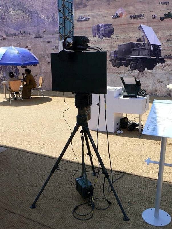
BEL Battle Field Surveillance Radar · around
Single sourcearound 30 kg[source]
Configuration
| Specification | AN/TPQ-37 Firefinder radar | BEL Battle Field Surveillance Radar |
|---|---|---|
| Speed | — | 0.9 m/s to 90 km/h[source]Source text · numeric interpretation needs review |
| Power | — | 80 W[source] |
| Role | mobile radar system[source] | — |
| Manufacturer | ThalesRaytheonSystems[source] | Bharat Electronics Limited[source] |
| Source measurement | AN/TPQ-37 Firefinder Weapon Locating System is a mobile radar system developed in the late 1970s by Hughes Aircraft Company , achieving Initial Operational Capability in 1980 and full deployment in 1984. Currently manufactured by ThalesRaytheonSystems , the system is a long-range version of "weapon-locating radar", designed to detect and track incoming artillery and rocket fire to determine the point of origin for counter-battery fire . It is currently in service at brigade and higher levels in the United States Army and by other countries. The radar is trailer-mounted and towed by a 2 + 1 ⁄ 3 -short-ton (2,100 kg) truck. A typical AN/TPQ-37 system consists of the Antenna-Transceiver Group, Command Shelter and 60 kW Generator. |
Crawling Man
Single sourceGroup of people
Single sourceHeavy Vehicles
Single sourceLight Vehicles
Single sourceWalking Man
Single sourceCrawling Man : 700 m (0.43 mi) Walking Man : 3 km (1.9 mi) Group of people : 7 km (4.3 mi) Light Vehicles : 10 km (6.2 mi) Heavy Vehicles : 14 km (8.7 mi)[source]
Bars compare reported quantities only. A larger figure does not make a system better; configurations and test conditions differ.
The AN/TPQ-37 is an electronically steered radar, meaning the radar does not actually move while in operation. The radar scans a 90-degree sector for incoming rocket, artillery and mortar fire. Upon detecting a possible incoming round, the system verifies the contact before initiating a track sequence, continuing to search for new targets. The incoming round/rocket is tracked during its initial upward/launch trajectory (i.e., the linear portion of its flight path) prior to reaching apogee. A computer program analyzes the track data and then extrapolates the round's point of origin. This calculated point of origin is then reported to the operator with map coordinates, thus allowing friendly artillery to direct counter-battery fire towards the enemy artillery. The system has a reported range of up to 31 miles (50 km). The system may also be operated in a friendly fire mode to determine the accuracy of counterbattery return fire.[source]AN/TPQ-37 Firefinder radar · Operation; only the objects and conditions stated in this passage
Azimuth sector: 1600 mils (90 degrees)[source]AN/TPQ-37 Firefinder radar · Main characteristics; only the objects and conditions stated in this passage
Prime power: 115/200 VAC, 400 Hz, 3-phase, 43 kW[source]AN/TPQ-37 Firefinder radar · Main characteristics; only the objects and conditions stated in this passage
Peak transmitted power: 120 kW, min.[source]AN/TPQ-37 Firefinder radar · Main characteristics; only the objects and conditions stated in this passage
Permanent storage for 99 targets[source]AN/TPQ-37 Firefinder radar · Main characteristics; only the objects and conditions stated in this passage
Automatic operation and high speed AHC using DTED Level II (30 meters between elevation points) to enhance accuracy of weapon location process.[source]AN/TPQ-37 Firefinder radar · Upgrades; only the objects and conditions stated in this passage
| — |
| Country of origin | United States[source]Country/countries explicitly given in the equipment row Origin column; not the country operating the row. AN/TPQ-37 Firefinder United States[source]Inventory Origin column; table 10, row 10, cell 3; revision 1375247138; retrieved 2026-10-02 | India[source] |
|---|
| Designer | — | Electronics and Radar Development Establishment ( DRDO )[source] |
|---|
| No. built | — | 1400+[source] |
|---|
| Frequency | — | J band[source] |
|---|
| Azimuth | — | 30-180°[source] |
|---|
| Elevation | — | -40 to +15°[source] |
|---|
| Precision | — | ±20 meters (66 ft)[source] |
|---|
| Other names | — | PJT-531[source] |
|---|
| Detection Range | — | Crawling man: 500 m Walking man: 2 km (1.2 mi) Group of people: 7 km (4.3 mi) Light vehicle: 10 km (6.2 mi) Heavy vehicle: 14 km (8.7 mi)[source] |
|---|
| Crawling man | — | 500 m[source] |
|---|
| Walking man | — | 2 km (1.2 mi)[source] |
|---|
| Group of people | — | 7 km (4.3 mi)[source] |
|---|
| Light vehicle | — | 10 km (6.2 mi)[source] |
|---|
| Heavy vehicle | — | 14 km (8.7 mi)[source] |
|---|
| Range accuracy | — | 20m rms[source] |
|---|
| Range resolution | — | 50 m[source] |
|---|
| Radar type | — | man portable 2D short-range battlefield and perimeter surveillance radar[source] |
|---|
| Reported operators | — |
|
|---|